
Other Enontekiö Hiking Trails
Demanding wilderness hiking in Enontekiö - the Pöyrisjärvi, Pulju, Tarvantovaara and Käsivarsi wilderness areas, the Kilpisjärvi region and the 800km Nordkalottleden (Calotte Route) trail to Halti, Finland's highest fell.
Enontekiö's wilderness areas hold some of the world's best hiking, with state-maintained cabins on almost every route. Hiking runs from mid June to the end of September, and July and August see the fells in blossom.
- Four wilderness areas: Pöyrisjärvi, Pulju (614 sq km), Tarvantovaara (670 sq km) and Käsivarsi (2,206 sq km)
- Halti, Finland's highest fell, reaches 1324m
- Nordkalottleden Trail: 800km total, 70km in Finland, 40 huts
- Three Nations' Border Stone in the Malla Strict Nature Reserve
- Always carry map, compass and overnight gear
Hiking in the Pöyrisjärvi Wilderness Area
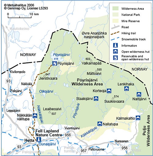
Pöyrisjärvi's rolling fell and forest landscapes make wonderful hiking, though the big bogs are best circled. There are no marked trails, but old unmarked routes show on terrain maps, and Everyman's Rights apply.
The Hetta-Näkkälä Marked Trail (26km) follows an old postal route marked with tall green poles topped by a white-red cross. The unmarked Kalmakaltio-Pöyrisjärvi-Näkkälä Trail (~93km) is extremely demanding, with rivers to wade. Carry a map, compass and proper overnight gear. The weather turns fast and it can snow even in summer.
Pulju & Tarvantovaara Wilderness Areas
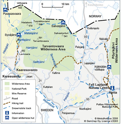
Pulju Wilderness Area (614 sq km, established 1991), with its large mires, hills and fells, suits experienced trekkers, and late-summer cloudberries draw day-trippers. A road and snowmobile track cross it from Nunnanen to Pulju, and reindeer husbandry remains a key livelihood.
Tarvantovaara Wilderness Area (670 sq km, established 1991) is a peaceful retreat where Whooper Swans nest in numbers. Try the Kultima-Leppäjärvi Trail (25km), also good for mountain biking, or the Palojärvi-Salvasjärvi Trail (20km), an old postal track that briefly crosses into Norway.
Hiking in the Kilpisjärvi Region
Kilpisjärvi, the main village in the arm of Finland, is the gateway to the Käsivarsi Wilderness Area and the Malla Strict Nature Reserve. Saana (1029m) is said to be Finland's best known fell, and the scramble to its top is eased by the longest set of stairs in Finland, two kilometres of wooden steps with lookout platforms.
Other trails include the Iitto Nature Trail (500m) across rare palsa moors, the Saana Trail (8km) and the Malla trail to the Three Nations' Border Stone (11km), where Finland, Sweden and Norway meet on a man-made island. Malla, established in 1916, is Finland's oldest nature conservation area.
Käsivarsi Wilderness Area & the Nordkalottleden Trail
Käsivarsi, Finland's second largest wilderness area (2,206 sq km, established 1991), holds every Finnish fell over 1000m bar Saana. One marked trail crosses it, the Kalottireitti / Nordkalottleden (Calotte Route).
- Length: 800km in total, 70km in Finland plus 380km in Norway and 350km in Sweden
- Most popular Finnish stretch: links Kilpisjärvi and Halti, Finland's highest fell at 1324m
- Huts: forty wilderness huts along the whole trail, 10 to 50km apart
- Difficulty: demanding and not for beginners, best from early July to mid September
- Classic loop: the Kilpisjärvi - Halti - Kilpisjärvi loop (c. 108km) takes about a week
Good to know
- Season
- Early July - mid September (high fells)
- Nordkalottleden Trail
- 800 km total, 70 km in Finland, 40 huts
- Käsivarsi
- 2,206 sq km, Finland's 2nd largest wilderness area
Ready when you are
Real wilderness, 200+ huskies, eighteen winters in.