
Central Wilderness Areas around Hetta
Enontekiö's three central wilderness areas - Pöyrisjärvi, Tarvantovaara and Pulju - vast roadless landscapes for experienced hikers, canoeists and fishers.
Enontekiö's central wilderness areas are Pöyrisjärvi (1,280 sq. km), Tarvantovaara (670 sq. km) and Pulju (614 sq. km), all established in 1991. Some websites list hiking trails under an 'Enontekiö Highland Watershed Area', which is simply the Pöyrisjärvi and Käsivarsi areas combined, so don't be confused. Outdoors.fi covers access by car and public transport, the relevant maps, and each area's history and nature.
- Pöyrisjärvi Wilderness Area: 1,280 sq. km, established 1991
- Tarvantovaara Wilderness Area: 670 sq. km, established 1991
- Pulju Wilderness Area: 614 sq. km, established 1991 - c. 40km from Hetta
- For experienced, self-sufficient hikers - mostly no marked trails, carry map and compass
- Angling and ice fishing are Everyman's Rights (with national fee + area permit for rivers)
- Struve Geodetic Arc UNESCO point atop Stuorrahanoaivi in Tarvantovaara
Pöyrisjärvi Wilderness Area
Pöyrisjärvi (1,280 sq. km) takes its name from the lake in its north, where impressive sand dunes and ridges rise. It suits experienced hikers with the right equipment and supplies: there are no marked trails, and while the rolling fell and forest make wonderful terrain, the large bogs are best circled, so you need to navigate reasonably well.
Many old unmarked trails do crisscross the landscape, as this has always been an important fishing, hunting and reindeer husbandry area. The Lapp villages of Kalkujärvi and Pöyrisjärvi lie within it, still inhabited for part of the year, and the two largest rivers, the Pöyrisjoki and the Käkkälöjoki, are especially good for canoeing and fishing, with fine mountain biking too.
Neighbouring protected areas include the Saaravuoma-Kuoskisenvuoma Mire Reserve to the south, Pulju Wilderness Area and Lemmenjoki National Park to the east and south-east, and Övre Anarjokka National Park across the Norwegian border. Reach it by car from Näkkälä, Vuontisjärvi or Kalmakaltio, or start from Hetta and connect to Näkkälä via the designated hiking and snowmobile trails.
What to do at Pöyrisjärvi
Walk: no marked hiking trails inside the wilderness area, but many well-worn old paths, used as a postal route at the beginning of the 20th Century. A marked trail passes just outside the boundary.
Canoe and row: the River Pöyrisjoki (source at Lake Pöyrisjärvi) and the River Käkkälöjoki are both excellent routes.
Fish: angling and ice fishing are Everyman's Rights, so no permit is needed for those (worm-bait angling and ice fishing are forbidden in flowing waters). River fishing requires the national fishing management fee plus an Enontekiö 1551 permit, and lure fishing the lakes a provincial lure fishing permit. Catches include whitefish, pike, perch, burbot, grayling and trout, with Lake Pöyrisjärvi dominated by whitefish of 200-300 grams.
Cycle, ski, hunt and pick: the paths offer demanding mountain biking (carry map and compass). Skiing is permitted all over the area, though no trails are maintained. Hunting needs permit 1615 Näkkälä or 1616 Nunnanen. Cloudberries are the prize in late summer and early autumn, with blueberries and lingonberries in the south and abundant mushrooms in the forests.
Pöyrisjärvi history and natural features
The area is rich in prehistoric finds, with Stone Age and early Metal Age settlements, hole-traps and seitas (places of worship) concentrated around Lake Pöyrisjärvi. So far 19 hole-trap sites, used for hunting wild fell reindeer, have been found. Fishing and hunting sustained people here for centuries, and before the Finland-Norway border closed in 1852, Sami from the Kautokeino area herded reindeer here.
The landscape shifts from dry pine forest on the south boundary, through birch, to treeless fell tops north of the lake, with the sand dunes, one of the area's most interesting sights, mostly on its northern side. Pöyrisvuoma is one of the largest mires in Enontekiö and one of Finland's most valuable palsa bogs, with around 50 frost mounds. The rarest mammal is the Arctic fox, and the bird-rich mires host 21 of Finland's 29 wader species.
Tarvantovaara Wilderness Area
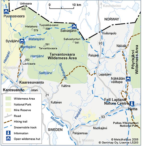
Tarvantovaara (670 sq. km) is a retreat for experienced hikers seeking peace, quiet and unforgettable nature. Together with the bordering Lätäseno-Hietajoki Mire Reserve it holds an extremely diverse bird population. The famous Finnish nature writer Yrjö Kokko spotted his first Whooper Swan's nests by a lake in these fells, inspiring his 1950 book about the swan, after which it was declared protected. Today they nest here in large numbers.
The area lies west of Leppäjärvi and north of Kaaresuvanto, its northern boundary following the Finnish-Norwegian border, where fell tundra rises to peaks over 600m. Forests are mainly fell birch and about a third of the area is mire, mainly palsa bog.
Two marked trails, the Kultima-Leppäjärvi and the Kaaresuvanto-Syväjärvi, are maintained and marked with kilometre posts (always carry map and compass). The Rivers Palojoki and Tarvantojoki suit beginner canoeists, bird-watching is superb, mountain biking is permitted on the trails, and the Hetta-Kilpisjärvi snowmobile track runs through the area via Palojärvi.
The Struve Arc: the top of Stuorrahanoaivi holds one of six Finnish points of the Struve Geodetic Arc, a UNESCO World Heritage Site, first marked in 1850 and engraved in stone with a cross. The German-born astronomer Friedrich Georg Wilhelm Struve used his survey triangulations to help determine the shape and size of the Earth in the 1800s.
Pulju Wilderness Area
Pulju (614 sq. km), c. 40km from Hetta, is known for its large mires and its many hills and fells, with Puljutunturi Fell rising to 471m in the south. It suits experienced trekkers, and its abundant late-summer cloudberries attract day-trippers.
- Access: a fairly large road with a snowmobile track runs through the centre from Nunnanen to Pulju, making access easy, and the track links on to Levi, Kittilä and Hetta
- Neighbours: Lemmenjoki National Park borders it to the east and Pöyrisjärvi Wilderness Area to the northwest
- Trails: no marked trails, but some clearly visible old tracks, including one of c. 10km from Kalmakaltio Spring towards Lake Pahtajärvi in Lemmenjoki National Park (drawn on the Lemmenjoki 1:50,000 map)
- Canoeing: you can canoe from Lake Korsajärvi into the head waters of the River Ivalojoki
- Fishing: angling and ice fishing are Everyman's Rights, with the relevant national fee and Enontekiö 1551 (or, on the Kittilä side, 1401) permits required for other fishing
- Berries: the road makes berry-picking easy, with plenty of cloudberries, blueberries and lingonberries in good years
Good to know
- Näkkälä from Hetta
- c. 25km north on road 93, then 14km east
Ready when you are
Real wilderness, 200+ huskies, eighteen winters in.