
Biking Routes South of Hetta
Old postal trails and forestry roads south of Hetta, plus the Hetta-Pallas trail that completes one of Europe's longest continuous mountain-bike routes.
A number of old roads criss-cross the north, some once early postal routes, others now used as forestry access. Beware that some bridges on these routes are not always in great repair.
- Ylimuonio - Puolitaival - Hetta: 38 km old postal trail with a rentable hut en route
- Hetta - Sonkamuotka via Muotkajärvi: c.37km easy forestry-road route
- Hetta-Pallas opened to bikers in summer 2017, completing a c.300km XC trail
- 900km of national-park trails, c.90km groomed in winter for fat bikes
Ylimuonio - Puolitaival - Hetta, 38 km, demanding
This old postal trail links Ylimuonio and Hetta, with an open hut at Puolitaival that can be rented if you wish to stay overnight en route. The northern 21km is effectively an old lost trail with only a few upright mile markings, while the second part (23km) has been digitally mapped.
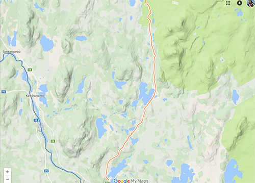
Easy trail from Hetta to Sonkamuotka via Muotkajärvi (c.37km)
An alternative between Muonio and Hetta takes the forestry roads branching off after Sonkamuotka, cutting the corner off the main road.
- Finding the turn: leave the asphalt just after a large layby, before a bridge under which a snowmobile route passes in winter
- The route: runs first south then west, two sides of a rectangle, through very pretty scenery
- Navigation: don't blindly follow the most-used trails, as the newest roads chase the felling and it is surprisingly easy to get lost
- Surface: lorry-wide gravel roads, generally drivable by normal cars but bumpy, so bring at least front suspension
Hetta-Pallas
The Hetta-Pallas trail within the Pallas-Yllästunturi National Park opened to bikers in summer 2017.
- One of Europe's longest: together with the existing trails it creates a continuous c.300km XC mountain-bike route, and from Hetta you can continue north for another c.200km to the Arctic Ocean
- Trail network: the national park alone has 900km of trails, with c.90km regularly groomed in winter, mainly for fat bikes
- Wilderness cafes: many routes link to unique wilderness cafes once reachable only by cross-country ski
Good to know
- Continuous trail length
- c.300 km (plus c.200km north to the Arctic Ocean)
- National park trail network
- 900 km (c.90km groomed in winter)
Ready when you are
Real wilderness, 200+ huskies, eighteen winters in.